
Return to Cornelius of Sunderland Passenger List
Messer Family Page: Pre-emigration generation A, 1, 2, 3, 4, 5, 6, 7, 8, 9,
10, 11, 12, 13, 14, 15, 16, 17, 18, 19, 20, 21, 22, 23, 24, 25, 26, 27, 28, 29, 30,
31, 32, 33, 34, 35, 36, 37, 38, 39, 40, 41, 42, 43, 44, 45, 46, 47, 48, 49, 50, 51,
52, 53, 54, 55, 56, 57, 58, 59, 60, 61, 62, 63, 64, 65, Index
William Messer (4 Dec 1799 – 21 Sep 1874)
and Alice (or Alison) Brown (~1795 – 19 Sep 1877)
Return to genealogical entry for William Messer familyMesser pre-emigration places of note
*************************************************
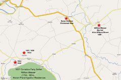
Map and satellite imagery showing location of Ford, Northumberland where William Messer married Alison Brown in 1826 as well as places where he was born and (some) places where he was variously employed in the 1820's and 1830's based on christening listngs for his children. He worked as a hind at Downham Farm in 1827 and 1829 and at Paston (Pawston) Farm in 1832. See photographs and information on the history of these farms below. Many of his children were christened at Crookham. Google map compiled: Tim Patterson, 27 Nov 2007.
Medium Sized
Pop-up Image
700 X 532 jpeg;
111 k; 72 dpiFull Sized
Pop-up Image
1000 X 665 jpeg;
325 k; 72 dpi
Medium Sized
Pop-up Image
900 X 626 jpeg;
260 k; 72 dpiFull Sized
Pop-up Image
1197 X 832 jpeg;
926 k; 72 dpi
Maps: Downham and Pawston (Paston ) farms
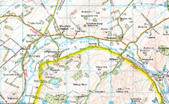
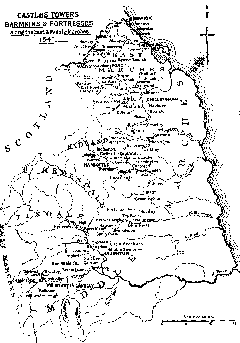
Left: Ordinance map showing position of the medieval deserted villages of Downham and Pawston (Paston) and other sites of interest in the area. Right: A map showing the official View of the Castles, Towers, Barmekyns, and Fortresses of the Frontier of the East and Middle Marches, drawn up with great care by Sir Robert Bowes and Sir Ralph Ellerker at the end of the year 1541, as transcribed by Bates. It should be noted that Bates in turn was transcribing a manuscript (The Cotton MS) which was an early copy of the lost original document. With reference to Downham: Sr Cuthbert Ogle clerke purchased yt & hath buylded thereyne an newe tower as yet but of two house heighte and not fully fenyshed by one house heighte and imbattlements nor not as yet any barmekyn. The preceding decription notes that a tower Pele Tower) had recently been built at Downham, most likely as a defence against Reiver raiders. In 1541 it was still incomplete and the battlements and surrounding enclosure had not been finished. There no remains to be seen of this tower today, and the precise location is not known. Fortifications are also found at Pawston. In the 1541 report it was noted that ...one Garrarde Selbye gent. of late purchased this towne and in yt hath buylded a lytle tower wthout a barmekyn not fully fynyshed. Source: The Gatehouse. http://homepage.mac.com/philipdavis/numblis4.html
Medium Sized
Pop-up Image
700 X 436 jpeg;
289 k; 72 dpiFull Sized
Pop-up Image
1160 X 723 jpeg;
1585 k; 72 dpi
Medium Sized
Pop-up Image
900 X 999 gif;
30 k; 72 dpiFull Sized
Pop-up Image
1370 X 1956 gif;
81 k; 72 dpi
Downham Farm
Downham Farm is the latest iteration of a very ancient settlement. The earliest evidence of human habitation at the site is an Iron Age hillfort (Reference number N847), known as Downham Camp, that lies on a sloping ridge immediately to the east of the modern farm. The structure is quite small and was thus not large enough to contain a community. It was therefore most likely a fortified farmstead The manmade defenses were given additional strength by the steep natural slopes, especially on the north side. There is also clear evidence that the top of the camp was cultivated in medieval times as there are visible traces of ridge and furrow across it.
Downham Farm is also the site of the Deserted Medieval Village (DMV) of Downham, which dates from at least the 13th century. In the post-medieval period the site became much smaller in size and all that survives now are a few slight earthworks in front of the modern farmhouse on the site. There are several DMVs in the area around Downham, which have since been abandoned or replaced by single farms such as Learmouth, where Reiver raiders almost destroyed the village, Mindrum and Moneylaws.
Why villages like Downham eventually disappeared occurred for many different reasons. Some declined after the Black Death in the 14th century. In Northumberland changes in the post-medieval economy resulted in a dramatic change in the social structure of the region, which also led to the abandonment of villages. Prior to the 18th century the most common agricultural set up was a post feudal open field system where each farmer farmed subsistence-cropping strips of land in one of three or four large fields held in common, and splitting up the products likewise. The demise of many villages was related to the consolidation of villages to a single farm, following the Inclosure Act fo 1801. About this time the cities in Breat Britain were growing rapidly as workers poured into them to fuel the industrial revolution. These workers needed to be fed. The 18th century British Agricultural Revolution came about when landowners realized that it was much more profitable to run a cash generating large-scale agricultural enterprise comprised of a series of large fields, rather than take in tiny rents from small scale independant farmers. The disenfranchised farmers either emigrated to the colonies, moved to the rapidly industrializing cities or ended up as various categories of agricultural worker such as hinds.
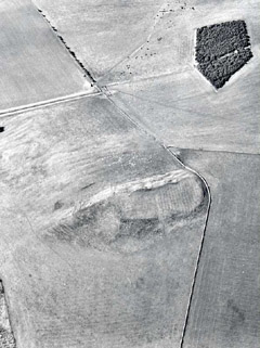
Left: Aerial photograph of the Iron Age Hill Fort, Downham Camp. Source: Tim Gates
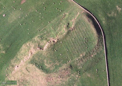
http://www.durham-pa.gov.uk/durhamcc/K2P.nsf/K2PDetail?readform&PRN=N847Right: Satellite image of Downham Camp, Iron Age Hill Ford. Source: Google map compiled: Tim Patterson, 30 Nov 2007.
Medium Sized
Pop-up Image
595 X 797 jpeg;
73 k; 72 dpi
Medium Sized
Pop-up Image
900 X 496 jpeg;
151 k; 72 dpiFull Sized
Pop-up Image
1069 X 757 jpeg;
636 k; 72 dpi
Medium Sized
Pop-up Image
700 X 418 jpeg;
127 k; 72 dpiFull Sized
Pop-up Image
1398 X 793 jpeg;
733 k; 72 dpi
Medium Sized
Pop-up Image
900 X 392 jpeg;
118 k; 72 dpiFull Sized
Pop-up Image
1372 X 769 jpeg;
854 k; 72 dpi
Medium Sized
Pop-up Image
700 X 419 jpeg;
140 k; 72 dpiFull Sized
Pop-up Image
1392 X 791 jpeg;
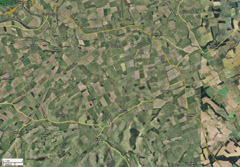
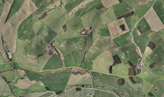
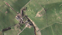
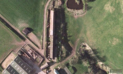
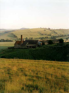
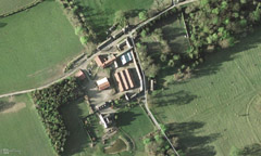
778 k; 72 dpiImages of Downham Farm. Upper left: satellite image of area around Downham Farm. Upper right: higher resolution image of Downham Farm with Iron Age hill top fort Dowham Camp clearly visible just to the east of the farm. Lower left: close-up of a portion of the farm showing the hinds cottages. Source: Google map compiled: Tim Patterson, 27 Nov 2007. Lower right: Fixed steam engines were gradually adopted by more prosperous farms such as illustrated here at Downham by early in the 19th century. Using cheaply available coal these engines were used to power processing equipment. At Downham the boiler was accommodated in the lean-to building with the tall chimney. Source: NMR (Negative no. BB95/09323). Ordnance Survey Map Grid Reference NT865339
Medium Sized
Pop-up Image
336 X 450 jpeg;
17 k; 72 dpi
References:
British Agricultural Revolution. Wikipedia. http://en.wikipedia.org/wiki/British_Agricultural_Revolution
Jobey, G., 1965. Archaeologia Aeliana (4th Series) 43, 62.MacLauchlan, H., 1919-22. History of the Berwickshire Naturalists Club 24, 464.
Ministry of Works, 1965. Ancient Monuments of England and Wales, 81.
Pawston (Paston) Farm
Pawston (Paston) is another Deserted Medieval Village that had it's demise associated with the 18th century British Agricultural Revolution. Gerard Selby of Branxton, Northumberland purchased the village and built a pele tower, later built up into a house, which he had occupied prior to 1541 " ... one Garrarde Selbye gent. of late purchased this towne and in yt hath buylded a lytle tower wthout a barmekyn not fully fynyshed". This Peler Tower was eventually torn down and replaced by a manor house, known as Pawston Hall, in the 18th century. The Selbys prospered here and the property remained in their family for the next 300 years, including the time when the Messer family worked here in the early 1830's.
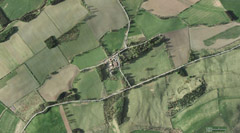
Left: Lower resolution satellite image of Paston (Pawston). Right: Zoom satellite image of Paston (Pawston). The Ordnance Survey Map Grid Reference is NT85533278. Source: Google map compiled: Tim Patterson, 27 Nov 2007.
Medium Sized
Pop-up Image
700 X 388 jpeg;
117 k; 72 dpiFull Sized
Pop-up Image
1404 X 779 jpeg;
823 k; 72 dpi
Medium Sized
Pop-up Image
900 X 421 jpeg;
140 k; 72 dpiFull Sized
Pop-up Image
1312 X 789 jpeg;
858 k; 72 dpi
Return to Cornelius of Sunderland Passenger List
Messer Family Page: Pre-emigration generation A, 1, 2, 3, 4, 5, 6, 7, 8, 9,
10, 11, 12, 13, 14, 15, 16, 17, 18, 19, 20, 21, 22, 23, 24, 25, 26, 27, 28, 29, 30,
31, 32, 33, 34, 35, 36, 37, 38, 39, 40, 41, 42, 43, 44, 45, 46, 47, 48, 49, 50, 51,
52, 53, 54, 55, 56, 57, 58, 59, 60, 61, 62, 63, 64, 65, Index